I've just returned from my day of touring the South Island. This is a such a beautiful place! I can't even begin to tell you.
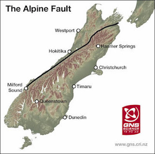
So, if you've ever been to the South Island you will have seen or at least heard of the Southern Alps. They run along the northwest edge of the island, which is exactly where the Alpine Fault is. Well that moves us on to our 3rd boundary type! The Alpine Fault forms a "transform" boundary between the Pacific Plate and Indo-Australian Plate. Located at 43°53'44.58"S 169°31'28.09"E, it runs the entire length of New Zealand's South Island, thus along the western edge of the Southern Alps. It also aligns with the Macquarie Fault Zone... Interesting... So, Transform boundaries are a bit more confusing than the others, so bear with me.
A transform fault or boundary is where the tectonic motion is primarily horizontal meaning they slide past each other. This lateral motion of one plate against another can show faults in the surface crust (As the Alpine Fault shows through the Southern Alps) The sliding motion also causes lots of earthquakes along the fault line.
Here is a record of the most recent earthquakes in relation to the Alpine Fault:
1848 - Marlborough, estimated magnitude = 7.5
1888 - North Canterbury, estimated magnitude = 7.3
1929 - Arthur's Pass, estimated magnitude = 7.1
1929 - Murchison, estimated magnitude = 7.8
1968 - Inangahua, estimated magnitude = 7.1
Most Recent:
2003 - Fiordland, estimated magnitude = 7.1
2009 - Fiordland, estimated magnitude = 7.8
Here is a diagram showing how Transform boundaries work:
This shows the Australian Plate and Pacific Plate:
This is clearly defined Alpine Fault (notice how it lines up with the mountain range):
An aerial view of the Southern Alps:
Well sadly this brings us to our last boundary! It's off to the United States. In fact, Seattle! Home sweet, home. Good planning on my part eh?
Talk to you in the good ole rainy Sea-town my loyal geology followers....


No comments:
Post a Comment