Friday, April 8, 2011

Hello!

Welcome to my blog on plate tectonics, featuring several extraordinary places around our globe.
First, let's start with the basics... I am a geologist (hopefully if you're on a tectonics blog, you know what a geologist is) and I belong to an agency called USGS (feel free to read more about it here: http://en.wikipedia.org/wiki/USGS).
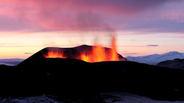
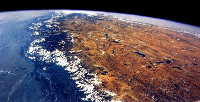
They've implored me to go on the organization's first international exploration trip, and learn about boundaries all over, not just near the United States. During the course of my expedition I will be visiting 4 particular places. Each are one of the 4 boundary types (convergent subduction, convergent collision, divergent and transform) as well as a hot spot. I will explain in detail how each boundary works in relation to the places in following posts. This blog will serve as my personalized way to communicate my experiences with people who also share my interest in earth science. 

Enjoy...


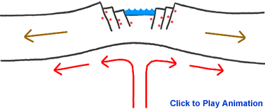
(This is a basic overview of plate tectonics and the arrows show their directional movement)


Thursday, April 7, 2011

First Stop: Iceland!

So it's been a great trip so far! Icelandair was a wonderful airline, and the man I sat next to also happened to be a retired geologist. We had a delightful conversation, and he was very intrigued by my trip. Flying in it was a bit overcast, but that's nothing new when one lives in Seattle! 
Here's a picture I took flying into Reykjavik, one of the larger towns in Iceland. I quite enjoy the colorful roofing....

Reykjavik 

As soon as I was out of the airport I indulged in the tourist side of me, wandering through the town. Once I'd finished I made my way for Grenivik, where my living situation has been arranged. Here's a picture of the turf house I'm staying in. I'm going to have that earthy aroma in my system for awhile...

Grenivik 

The landscapes are simply gorgeous here. And the people, let me tell you, are just the nicest. (Despite the fact I can barely understand them) 

Well time to hit the sack! I need to get some sleep for tomorrow where I'll be visiting the first stop on my map. 

More tomorrow night my fellow science enthusiasts...


Wednesday, April 6, 2011

Hot spot

I've just returned from the first stop! The great Eyjafjallajӧkull. A subglacial volcano located on the southern coast of the large island, to be specific: 63˚38'N 19˚36'W.
Wow.... was all I could say when I arrived. Indeed I could've been saying 'wow' to the ridiculous temperatures, but it was the breathtaking white caps, and stunning terrain that thrilled me the most. 
So why am I tell you about it? Well this volcano is a Hot spot. Were not talking WiFi, but rather a volcanic region that is created by mantle that is especially hot compared to other places. No one knows the exact reasoning as to why these form, but one hypothesis are "mantle plumes" (a hypothetical idea) that hot rock rises from the core through the Earth's mantle. 
Some of these volcanoes occur on plate boundaries and others far away. (Hawaii is a hot spot located in the middle of the Pacific, not even in proximity to a boundary)
Iceland happens to be one of the most volcanic regions in the world (located on a divergent boundary line) Could it be because of this "hot spot" phenomenon? Who knows, maybe you'll be the one to figure it out...


Here is a map showing the volcanic activity on Iceland:

File:Volcanic system of Iceland-Map-en.svg

Here is a diagram of Hot Spots:


And here is the result:


http://alyssakent.files.wordpress.com/2010/04/iceland-eyjafjallajokull-volcanic-eruption-up-close-vs-pronounce-that-name-lol-hd-raw-video-1.jpg
Sadly, all great days must come to an end, so goodnight and hopefully I'll being sharing my next tectonic adventure with you in the next 2 days or so...

Goodbye Iceland!

Sunday, April 3, 2011

The Red Sea

Hello again! I've made my way to Saudi Arabia, and have just returned from a boat tour around the eastern coast of the Red Sea. A divine body of water, situated between Africa and Asia, at 22˚N 38˚E, it holds more than 1,200 species of fish. 


(Both images are from http://en.wikipedia.org/wiki/Red_Sea)

Anyways, moving on to the science. We have reached our first boundary! Whoo hoo! Get excited people. The Red Sea is an effect of the "divergent plate" boundary. How so? Well divergent plate boundaries are when two plates are moving away from one another. You see, the Red Sea was formed when Arabia split from Africa due to the Red Sea Rift. Valley rifts are a common result of divergent plate boundaries. This rift is a spreading center between the two plates. Still confused? Okay, so when the plates pull apart, central blocks slide downwards on either side of the rift. In the beginning process, streams and rivers will flow into the sinking valley to form a long linear shaped lake (note the shape of the Red Sea... looks long and linear to me...) When the rift grows deeper it drops below sea level permitting ocean waters to flow in, producing a sea within the rift. Rifts can grow deeper and wider and ocean basins can be produced. Divergent boundaries, in this case, created a new sea-floor and a widening ocean basin we all know as the Red Sea. (See diagram below)


Geologists, including myself, predict that in the future (we're talking super far ahead) that the Red Sea could become an ocean. For now it's just an Atlantic wannabe, (the same thing happened with the Atlantic Ocean)
 but we'll see or should I see the future generations will see.... 

But for now it's just a beautiful tropical sea.... Off to colder places, yet again, for our second boundary stop! 


Saturday, April 2, 2011

Nepal

Namaste. That's hello in Nepali! 
They have had beautiful weather here. A bit chilly, but simply stunning. 
I have been staying in a village called Ghandrung for the past two days and my host family is wonderful. It was very kind of them to let me stay in their home. The food is delicious. The people are fascinating. And the views are jaw dropping.

These are the Himalayas in the rising sun from my window:


Some fantastic Napalese food I had for dinner yesterday:


These are the two children who live in the house I'm currently staying at:


Anyways, it's getting late and I'm trekking up to the mountains tomorrow morning at sunrise, so I better be going....


Thursday, March 31, 2011

Himalayas

The most spectacular mountain range on planet Earth. Containing the worlds highest peaks, it is certainly quite a sight. I, being no great mountaineer went trekking in the lowlands and returned late last night. 


It was extremely cold, but the mountains were stunning, so it was all worth it. We have reached our second boundary type! So here goes the science....
 The Himalayas are a result of the "Convergent Collision" boundary type, located at approximately: 27°59′17″ N  86°55′31″E
Convergent collision is where two plates move towards one another, resulting in a continental collision. The plates resist subduction and the crust of the plates moves up, raising land creating mountains where a trench would be. This process is called Orogeny. Orogens develop when the continental plate is somewhat "crumpled" to form mountain ranges. The Himalayas were formed when India "collided" with Asia, so when the northern moving Indo-Australian Plate merged into the Eurasian Plate. The plate pushed up into the other creating the Himalayas, referred to as a "fold mountain." Each year, the Indo-Australian plate moves 67 mm north into Eurasia. This means that the highest peaks in the world are growing taller yet, every moment! (To be exact, they rise 5 mm per year meaning they are geologically active.)

This is a great picture, depicting India's journey over the years: 

http://en.wikipedia.org/wiki/File:Himalaya-formation.gif


Diagram of the Himalayas and tectonics: 


http://www.moorlandschool.co.uk/earth/earth_science/Himalayas_collision.gif


The gorgeous Himalayas: 


http://media.nowpublic.net/images//70/d/70d2b6e0e5f3d8894f4420299b838b17.jpg

K2, the second highest peak:

http://images.wikia.com/synchromystic/images/0/07/K2.jpg

The peaks along with the Tibetan Plateau: 


http://mapstor.com/data/images/articles/mountain-formation/tibet-himalayas-from-space.jpg


Hope you are enjoying the blog so far! Now I'm off to New Zealand for our second to last boundary. I'll update you soon...
Feri Bhetaula!


Saturday, March 19, 2011

Side stop... New Zealand!

So welcome back. I've decided to take a day or two off from geology and soak up some rays.
I'm staying in a hostel in Auckland. I couldn't resist the absolutely stunning scenery!

Here are some pictures I took after a long day of sightseeing.... Enjoy!

This is the marina:


This seems really familiar... where have I seen such similar architecture before...


Piha Beach:


Simply ravishing: 


Well that's all for now. Wishing you were here? That's what I thought... More to come!

Thursday, March 10, 2011

Alpine Fault

I've just returned from my day of touring the South Island. This is a such a beautiful place! I can't even begin to tell you. 
So, if you've ever been to  the South Island you will have seen or at least heard of the Southern Alps. They run along the northwest edge of the island, which is exactly where the Alpine Fault is. Well that moves us on to our 3rd boundary type! The Alpine Fault forms a "transform" boundary between the Pacific Plate and Indo-Australian Plate. Located at 43°53'44.58"S  169°31'28.09"E, it runs the entire length of New Zealand's South Island, thus along the western edge of the Southern Alps. It also aligns with the Macquarie Fault Zone... Interesting... So, Transform boundaries are a bit more confusing than the others, so bear with me.
A transform fault or boundary is where the tectonic motion is primarily horizontal meaning they slide past each other. This lateral motion of one plate against another can show faults in the surface crust (As the Alpine Fault shows through the Southern AlpsThe sliding motion also causes lots of earthquakes along the fault line.
Here is a record of the most recent earthquakes in relation to the Alpine Fault:

1848 - Marlborough, estimated magnitude = 7.5
1888 - North Canterbury, estimated magnitude = 7.3
1929 - Arthur's Pass, estimated magnitude = 7.1 
1929Murchison, estimated magnitude = 7.8 
1968Inangahua, estimated magnitude = 7.1 
Most Recent: 
2003Fiordland, estimated magnitude = 7.1
2009 - Fiordland, estimated magnitude = 7.8

Here is a diagram showing how Transform boundaries work: 

This shows the Australian Plate and Pacific Plate:


This is clearly defined Alpine Fault (notice how it lines up with the mountain range):


An aerial view of the Southern Alps:


Well sadly this brings us to our last boundary! It's off to the United States. In fact, Seattle! Home sweet, home. Good planning on my part eh? 
Talk to you in the good ole rainy Sea-town my loyal geology followers....


Wednesday, March 9, 2011

Rainy Rainier

Well this brings me to our last boundary... It also returns me to my home town, Seattle. Rain, rain and more rain is all I can say. It makes me wonder why I ever came back. And then I remember the lovely volcano, Mount Rainier. This local phenomenon is a result of the last boundary type called "convergent subduction"


http://tasaclips.com/illustrations/Convergent_Boundary.jpg


Well great, but what on earth does that mean? It is when two plates move towards one another (in this case oceanic and  continental) and one slides under the other. (This also forms a trench at the convergence point.) The oceanic plate slides beneath the continental plate because it is denser. You may be thinking "What? How come?" Well here is a simplified explanation. Imagine you have a cup of water with Styrofoam pieces in it. Naturally the Styrofoam will rise to the top because it is lighter. The continental plate is the less dense Styrofoam. 
So now back to how this made a volcano. Well, when the oceanic plate (Juan de Fuca)  slides under the continental plate (North American Plate), it sinks into the Earth's mantle which we all know is extremely hot. It melts the rock, creating magma, which rises because it is less dense than the rock. These magmas continue rising until they get to the earth's surface, producing a volcanic eruption. Subduction zones are a basis for long chains of volcanoes called 'volcanic arcs' that are parallel to the zone.
Mount Rainier is a stratovolcano that is part of the Cascadia Subduction Zone, located in the Cascade Range at 46˚51'10"N 121˚45'37"W.  It happens to be the most prominent mountain in the contiguous U.S. and has an elevation of 14,411 ft. It's prominence is 7 meters greater than that of K2. (WOW!) Because of it's structure and internal chemistry it is one of the most  dangerous volcanoes. If it were to erupt, it could produce massive lahars as it did 5,600 years ago when it's wall of mud covered 130 square miles. Lahars can destroy anything their path because of the extreme force/speed. Even worse, when it finally stops moving, the mud 
solidifies creating even more problems. 
Although it's last eruption was in 1884 it has landed itself on the Decade Volcano list, earning perpetual investigation of its dangers, and future eruption possibilities.


The following volcanoes were selected as the 16 current Decade Volcanoes:  

  But let's not worry about that right now, and just enjoy the marvelous views it provides:


So unfortunately this brings me to say goodbye. I have loved being able to share my experiences with you, and with bit of luck, hopefully you learned a little about plate tectonics. 
Thank you for your support! I can't wait to see what the USGS thinks of my travels...

Adieu fellow geologists, and keep up your interests in Earth science! The learning never ends!


Tuesday, March 8, 2011

If you were a fan....

Hello everyone!
So if you have been following my trip then you will probably enjoy watching my tectonic tour I made to go along with my trip. It was made in Google Earth, and is from a birds eye view: 

Click the link to view! 


(You'll have to download it to watch it--Sorry!)

Thanks for being such great followers! 

Sincerely, 
Sadie